Monday 1 June 2020

Old Buildings Aurora Ontario Canada


The community was first known as Machell's Corners and had only 100 residents in 1851. The population of Aurora in 1863 was 700, and by 1869 it had grown to 1200. The settlement was incorporated as a village in 1863 with Charles Doan as the first reeve.

Aurora (2016 population 55,445) is a town in central York Region in the Greater Toronto Area, within the Golden Horseshoe of Southern Ontario, Canada. It is located north of the Town of Richmond Hill and is partially situated on the Oak Ridges Moraine. In the Canada 2016 Census, the municipal population of Aurora was the 95th largest in Canada, compared to 97th for the 2006 Census. Aurora has been ranked in the top 10 wealthiest towns in Canada


Lieutenant-Governor John Graves Simcoegave the order for Yonge Street to be extended to Holland Landing in 1793, the first step toward the establishment of a community where Aurora now stands. Yonge Street opened between 1794 and 1796. In 1795, the first house in Aurora was built at Yonge St and Catherine Av. The government began granting deeds to land in 1797. By 1801 there were fourteen homes.

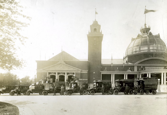
In 1804, Richard Machell became the first merchant at the crossroads of Yonge and Wellington and the hamlet soon became known as Machell's Corners. Charles Doan was another early businessman at Machell's Corners and became the first postmaster and later the first reeve. The post office was originally known as "Whitchurch".As postmaster, he was influential in renaming the village Aurora, after the goddess Aurora from Roman mythology.[7]:10[a] Machell proposed to rename the town "Match-Ville", ostensibly for the match factory in the town, but the name Aurora was more popular and ultimately chosen as the town's name.[12 Flour and grist mills were built around 1827. With the coming of the railway in 1853, Aurora emerged as an important centre north of Toronto. The Fleury plough works foundry opened in 1859, making agricultural implements.
The community was first known as Machell's Corners and had only 100 residents in 1851]The population of Aurora in 1863 was 700, and by 1869 it had grown to 1200.
The settlement was incorporated as a village in 1863 with Charles Doan as the first reeve. Records from 1885 describe Aurora as the "largest village in the county" an "enterprising and stirring business community" with several factories and mills, five churches, a school house with 210 students, and two weekly newspapers. The population in 1881 was 1540.The population reached 2,107 by 1888.
Aurora was the childhood home of Lester B. Pearson, Prime Minister of Canada from 1963 to 1968, when his father, Rev. Edwin Pearson, was the Methodist minister 40
Aurora is noted for preserving its historical built form and in 2008 was awarded The Prince of Wales Prize for Municipal Heritage Leadership.] In 2009 the town received the Lieutenant Governor's Ontario Heritage Award for Community Leadership in heritage conservation and promotion.Northeast Old Aurora was designated in 2006 as a provincial Heritage Conservation District.
On April 8, 2010, the town re-opened the historic and fully renovated Church Street School as the Aurora Cultural Centre.
Aurora is twinned with Leksand, Sweden.
The Aurora armoury is a recognized Federal Heritage building, listed in 1991 on the Register of the Government of Canada Heritage Buildings.
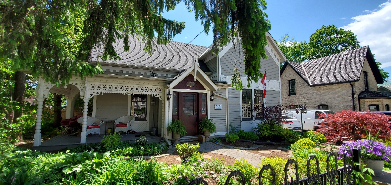
Aurora is also home to Hillary House and Koffler Museum of Medicine. Hillary House is recognized by the National Historic Sites and Monuments Board as one of Canada's best examples of Gothic Revival architecture.
Peoples

The first train arrived on May 16, 1853. 
The old station, which has survived to the present with some minor alterations.

Monday 23 March 2020

Star Forts

At the present moment 2020  there were discovered over 6000 star forts using Google map technology.

There are a huge number of different styles and designs of starfort - and on closer examination, they clearly had various uses and functions.
Variety was very important to the civilisation that built the starforts, consequently there are many variations based on a common theme.

The most common 'types' (presumably for living in, use as residencies and outposts, places of worship maybe, etc) are listed below.
These designs are intermixable and interchangeable, but we have to start somewhere!

We are attempting to develop a more in-depth set of descriptions for the structures involved in the starfort phenomenon, so that we can all understand one another when we are talking about the various different types. It will also help us, long term, to understand which structures were used where - and perhaps their function - and that they may not be 'forts', at all!


 Star 5-point

Example: Kastellet in Copenhagen, Denmark.

55°41'29.31" N 12°35'40.88" E

This lovely five-pointer still has it's original surrounding canal system intact. There are a quite a few of these still surving today, in many parts of the world - though most are no longer connected to the canal system they were originally a part of.

Five-pointers measure, on average, approx 250-400m from tip of one spear to the opposite side wall. Size can vary.

Almost always built on flatter ground with access to a main canal, they are also found in very close proximity to starcities, often forming the 'hedgehog' formation when attached to a starcity.

  Star 4-point

Example: Holic in Slovakia.

48°48'31.61" N 17°09'24.57" E

A well preserved four-point example in Slovakia.

There are many different regional variations of four-pointers - for instance, they get very 'spiky' in Spain and more 'pointy' in Russia,

 Star Megalopolis

Example: Floriana in Malta.

35°53'35.84" N 14°30'19.11" E

A massive construction involving many, many different aspects of the star civilisation's buildings and styles.

Alas, some of it now underwater, we suspect!

 StarHub

Example: Palmanova in Italy.

45°54'17.69" N 13°18'35.79" E

StarHubs have between 6 and 12 'points' i.e. Palmanova is a nine-point assymetric StarHub.

It will have been connected into the canal system in the same way everything else was within the star civilisation. You can actually walk around this city using GoogleEarth StreetView - check out where the canals used to be in what looks like the dried up moats surrounding the entire city. We know they're not moats though :)


 Star Hedgehog

Example: St. Martin De Re in France.

46°12'10.09" N 1°21'55.73" W

A Hedgehog incorporates both a Starhub and a four or five point star structure. 


Indonesia Star Fort.
 
 Utrech Neederland


Auxilliary structure at Utrecht, Netherlands


Advanced - the auxilliary structures, canal and crop systems that you may not have been aware were part of the Starfort civilisation.

These are the structures associated with the Star Civilisation that are not starhubs, hedgehogs, castles, five point or four-point structures.

They were connected to the system by a series of canals, which ranged in size from hundreds of metres across right down to tiny irrigation tracts.


There are a large number of these structures (some are still described by the mainstream as 'forts'), with a multitude of shapes and sizes, but all of them bear the distinctive aesthetic look and feel of the star civilisation. As our knowledge of the star civilisation grows, more will become apparant - and we may be able to work out their particular functions.

Many more of them were still present throughout the world in the 1940's and 1950's than compared to today - although the overgrown remnents of many still exist if you know what to look for.


Canal System

The entire star civilisation was linked together by an enormous and complex system of canals. From massive canals that linked major star cities and megalopolis, to comparitively tiny ones that irrigated  their crops - they were all part of an intricate, balanced and extremely effective means of transport and communication.

Later, many of the medium sized and smaller canals were filled in - and became the foundations for our road systems today.

Romania

Palanca, Romania 1720

Sp_Vipalancka_Banatska-Palanka-1720_0001_2.jpg

Severin, Romania c1800

Found this drawing from c1800 marked as Orsova - but there's no islands in the river around Orsova, but just down the river at Severin there's the mostly covered ruins of a starfort - 44°36'41.13" N 22°41'09.08" E - maybe it's that. Looks like quite a bit of it may have been washed away.


Vienna, Austria 1780 1806


Links


Wednesday 4 March 2020

Lost Buildings of Toronto

What happened in Canada in 19 century? 
How do you imagine Toronto 150 years ago?
Here are some pictures from the Toronto Archives.


Pavilion, Horticultural Gardens (Toronto, c.1900) Demolished

Picture, 1907, English
Notes Inscribed in the print, l.c.: Pavilion, Horticultural Gardens.; Letterpress, in dark greyish red ink, u.l.: COMPLIMENTS OF / GERHARD HEINTZMAN, LIMITED / 97 YONGE STREET, / TORONTO.; Inscribed in pencil (by T.A. Reed), u.r.: cir 1895; In pen and black ink, vso t.: Pavillin Horticulturol Gardins
No records of who built it when was built.

 Kids in the field out front of Knox College (1875-1915), 1 Spadina Crescent. Toronto
138 years ago - 1882


Osgoode Hall before the dome, between the west wing and library, was removed
(Categorized under: Osgoode Hall )
1852 - City Hall

Osgoode Hall Library interior - stereo - Photographed by Armstrong, Beere & Rime, Toronto
(Categorized under: Osgoode Hall )
1859 - City Hall

 Osgoode Hall gates and pedestrians - half-tone photograph
(Categorized under: Ornamental gate --- Osgoode Hall )
  Saturday, April 23, 1870 - City Hall


Osgoode Hall Library with ornate ceiling and fireplace
(Categorized under: Osgoode Hall )
136 years ago - 1884 - City Hall


 The Independent Order of Foresters (IOF) built a grand arch . It was built in 1901, complete with flashing light bulbs, flags and crests, and a crown on the top, and was illuminated at night.  

It originally stood across Bay Street (Terauley Street at the time) at Richmond, just south of City Hall, outside the Temple Building (also known as Foresters' Temple or the the I. O. F. Temple). It was moved to the Exhibition Grounds by 1906. 
Now Demolished 

 Caer Howell Hotel (University Ave. at Orde St.)
(Caer Howell Hotel )
  1900 - Discovery District

Links
http://wholemap.com/historic/toronto.php?neighbourhood=City%20Hall

http://wholemap.com/historic/toronto.php?neighbourhood=Downtown 

http://wholemap.com/historic/toronto.php?neighbourhood


Tuesday 3 March 2020

Canadian National Exhibition Toronto, Ont.--Lost Architectural Buildings and Cultural History of Toronto

We Should ask why this concerted effort to destroy old buildings and old architecture of this city?

Who are the peoples behind it?
Are these buildings erased form the public consciousness? 
Canada is a large Country. There is plenty of space. Why not build beside them ? 
Why were these buildings destroyed?
In Europe they would have been rebuilt. Have we lost the ability to build such artistic buildings?
Has the consciousness of people something to do with it?

When people see beauty the spirit is uplifted. Is the reverse also true?
 

On the Terrace showing Manufacturers' and Women Building, Toronto Exhibition by night. Toronto, Ont.- All Buildings demolished

Picture, 1914,


Grand Plaza, showing Manufacturers' Building, Toronto Exhibition, Canada


Picture, 1912, English


Medium Printed ephemera. Postcard


Entrance to Manufacturers' Building, Exhibition, Toronto

Picture, 1910, English

Rights and Licenses Public Domain Medium Printed ephemera. Postcard


C.N.E. Horticultural Building. Demolished , showing south entrance

Picture, 1920, English


Crystal Palace - Demolished


C.N.E. Transportation Building Demolished

Picture, 1920, English
 Notes Inscribed in the photograph l.r.; Photographer's stamp on vso. See also TORONTO/C.N.E./BUSINESS MACHINES BUILDING. TEC 21.5A 

Entrance to Grand Stand, Toronto Exhibition, Canada

Picture, 1910, English
NotesInsc. l.r.: 105948. Insc. vso. Printed in Great Britain. C.N.E. Grandstand (1907-1946)Rights and Licenses Public Domain
 

Women's Building (1908) Demolished

Picture, 1952, English
Notes Salmon's negative envelope & print gave dates June 1952 & July 1952 respectively
 Rights and Licenses Public Domain Medium Film negative Call Number / Accession Number S 1-733

Collins Wireless Telephone Exhibit

Picture, 1909, English
Notes Copy photograph: E 4-96d. REPRO of E 4-96d. TEC 22A Rights and Licenses Public Domain Medium ½ plate glass copy negative
Branch Toronto Reference Library Location
Baldwin Collection Call Number / Accession Number E 9-251 Small

Horticultural Building -Demolished, looking north

Picture, 1952, English
Rights and Licenses Public Domain Medium Film negative Call Number / Accession Number S 1-715B 


Horticultural Building - Demolished

Picture, 1928  


Horticultural Building - Demolished


Dominion and Provincial Government Building, Toronto Exhibition - Demolished

Picture, 1915, English


Government Building - Demolished

Picture, 1913, English 


Entrance to Ontario Government Building, Canadian National Exhibition, Toronto. Demolished

Picture, 1928, English
Notes Inscribed in pencil, l.l.: Entrance Ontario Government Building / Canadian National Exhibition / Toronto-Canada; l.r.: W.H. Edwards

Ontario Government Building - Demolished

Picture, 1929, English 

Government Building, Toronto Exhibition, Canada - Demolished

Picture, 1915,

C.N.E., Graphic Art Building Demolished

Picture, 1900, English 

Art Gallery  - Demolished ( possible same building as Graphic Art Building)

Picture, 1952, English 

On the Grand Plaza, Canadian National Exhibition. Toronto, Canada - Fountain Removed

Press Building (1906) - Demolished

Picture, 1953, English 

Canadian National Exhibition. Administration Building - Demolished

Crystal Palace (1879-1906) - Demolished (Mud Flood?)

Picture, 1880, English 
Crystal Palace

Crystal Palace (1879-1906) Demolished

Picture, 1905,

Automotive Building - Demolished

Picture, 1956, English 


Automotive Building; Interior - Demolished

Picture, 1954

Scene in front of Manufacturers' Building Canadian National Exhibition, Toronto

Picture, 1906, English 
Another Scene from Manufacturer Building 


Manufacturers Building

Picture, 1913

CC.N.E. Transportation Building - Demolished

Picture, 1923, English

Notes

Inscribed in the photograph l.r.: X29485. TEC 21.5B
See also TORONTO/C.N.E./BUSINESS MACHINES BUILDING.
Anotherr View of the building

Transportation Building, Industrial Exhibition, Toronto, Canada - Demolished

Picture, 1903, English

Notes

Formerly known as the Crystal Palace (1879-1906)
Other View

Crystal Palace (1879-1906)  - Demolished

Picture, 1884, English
Notes Copy negative shows printed caption below photograph. Copy photos: E 4-95a; B 5-83a.
Perhaps from 'Picturesque Toronto', Toronto, 1885


Coliseum, Exhibition Place, Toronto, Ont. Demolished

Hornyansky, Nicholas, 1896-1965

Livestock Building - Demolished

Picture, 1913, English 

Electrical Building - Demolished

Railways Building - Demolished

Picture, 1952, English
Notes Building became Hydro Building in 1953, and later became Music Building. See also TORONTO/C.N.E./MUSIC BUILDING See also TORONTO/C.N.E./HYDRO BUILDINGRights and Licenses Public Domain
 

Agricultural Implements Hall, showing Association Offices at right  - Demolished

Picture, 1890,

Transportation Building, Interior - Demolished

Picture, 1913, English 

Women's Building - Demolished

Picture, 1906, English
Notes
Inscribed by Salmon in dark blue ballpoint pen, vso u.l.: CNE Woman's Building 1906 Shows inscription in the print, l.l.: Galbraith I Photograph Co. / Toronto Can.; The copy negative shows inscription (on mount?) l.r.: WOMAN'S / BUILDING


Grandstand (1907-1946) Demolished

Picture, 1920, English 

Band Shell - Demolished

Picture, 1952, English 

Band Concert, Toronto Exhibition, Canada

Picture, 1912

The Mysterious Vatican

Resonate design columns display a low frequency rate at the tops of the columns and transitions to a high frequency design at bottoms. At th...